Dosya:EU-Poland.svg

Bu SVG dosyasının PNG önizlemesinin boyutu: 713 × 600 piksel. Diğer çözünürlükler: 285 × 240 piksel | 571 × 480 piksel | 913 × 768 piksel | 1.218 × 1.024 piksel | 2.435 × 2.048 piksel | 2.045 × 1.720 piksel.
Orijinal dosya (SVG dosyası, sözde 2.045 × 1.720 piksel, dosya boyutu: 7,33 MB)
польша
Özet
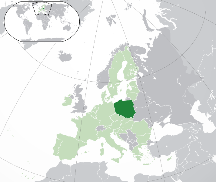
Polski:
(Green) Polska.
(Light-green) Unia Europejska (UE).
(Gray) Europa.
(Light-gray) Inne terytoria.
| Açıklama |
English: (Dark-Green) Poland. (Light-Green) The rest of the European Union (EU). (Dark-gray) The rest of Europe. (Light-gray) The surrounding region.
See also: |
| SVG gelişimi | Bu geniş W3C-geçersiz vektörel grafik Inkscape ile oluşturuldu. |
| Tarih | |
| Kaynak | Own work based on: Location European nation states.svg |
| Yazar | NuclearVacuum |
| Diğer sürümler |
|
| SVG gelişimi | Bu geniş W3C-geçersiz vektörel grafik Inkscape ile oluşturuldu. |


Lisanslama
Ben, bu işin telif sahibi, burada işi aşağıdaki lisanslar altında yayımlıyorum:
Bu dosya, Creative Commons Atıf-Benzer Paylaşım 3.0 Taşınmamış lisansı ile lisanslanmıştır
- Şu seçeneklerde özgürsünüz:
- paylaşım – eser paylaşımı, dağıtımı ve iletimi
- içeriği değiştirip uyarlama – eser adaptasyonu
- Aşağıdaki koşullar geçerli olacaktır:
- atıf – Esere yazar veya lisans sahibi tarafından belirtilen (ancak sizi ya da eseri kullanımınızı desteklediklerini ileri sürmeyecek bir) şekilde atıfta bulunmalısınız.
- benzer paylaşım – Maddeyi yeniden karıştırır, dönüştürür veya inşa ederseniz, katkılarınızı orijinal olarak aynı veya uyumlu lisans altında dağıtmanız gerekir.

|
Bu belgenin GNU Özgür Belgeleme Lisansı, Sürüm 1.2 veya Özgür Yazılım Vakfı tarafından yayımlanan sonraki herhangi bir sürüm şartları altında bu belgenin kopyalanması, dağıtılması ve/veya değiştirilmesi için izin verilmiştir;
Değişmeyen Bölümler, Ön Kapak Metinleri ve Arka Kapak Metinleri yoktur. Lisansın bir kopyası GNU Özgür Belgeleme Lisansı sayfasında yer almaktadır. |
İstediğiniz lisansı seçebilirsiniz.
Dosya geçmişi
Dosyanın herhangi bir zamandaki hâli için ilgili tarih/saat kısmına tıklayın.
| Tarih/Saat | Küçük resim | Boyutlar | Kullanıcı | Yorum | |
|---|---|---|---|---|---|
| güncel | 05.19, 1 Şubat 2020 | | 2.045 × 1.720 (7,33 MB) | Rob984 | UK and Gibraltar have left the EU. New base which includes all of Portugal's islands within frame, as well as Arctic Russian islands part of Europe. Also fixed Flevoland in the Netherlands. |
| 20.34, 25 Ekim 2016 |  | 2.045 × 1.720 (7,32 MB) | Giorgi Balakhadze | fix | |
| 09.25, 24 Aralık 2015 |  | 2.045 × 1.720 (7,33 MB) | Nordwestern | Per original framework and Commons' rules. Agree with A2D2. | |
| 15.58, 18 Mart 2015 |  | 2.045 × 1.720 (7,38 MB) | Mapclean | Reverted to Leftcry's version, please go to your talk page | |
| 14.10, 21 Şubat 2015 |  | 2.045 × 1.720 (2,61 MB) | VS6507 | Spain. Greece. Slovakia. Cyprus. Romania VETO | |
| 19.34, 16 Kasım 2014 |  | 2.045 × 1.720 (7,38 MB) | Leftcry | Reverted to version as of 15:48, 6 August 2014 Please go to your talk page | |
| 16.36, 16 Kasım 2014 |  | 2.045 × 1.720 (2,61 MB) | A2D2 | The map must show the original de-jure status with no breakaway regions, as it was originally created. An alternative map showing the de-facto status with breakaway regions needs to be created instead. | |
| 15.48, 6 Ağustos 2014 |  | 2.045 × 1.720 (7,38 MB) | Rob984 | Improved version: More accurate coastline, borders, etc. Added Gradient and Longitude and latitude lines. Sudan border. | |
| 09.31, 1 Temmuz 2013 |  | 2.045 × 1.720 (2,61 MB) | U5K0 | croatia | |
| 14.41, 23 Ekim 2009 |  | 2.045 × 1.720 (2,59 MB) | NuclearVacuum | consensus version |
Dosya kullanımı
Aşağıdaki 3 sayfa bu dosyayı kullanmaktadır: